

Category Archives: Waterfalls – Cataratas
PLAYA ARCO (Parque Nacional BALLENA National Park)
Playa Arco is one of the most beautiful beaches in Costa Rica. It is roadless, so you can only get there by foot or by sea. The hike starts at the entrance for Ballena (Spanish for whale) National Park.
To get there, drive south on the Costanera Sur (Pacific Coast Hwy) from Dominical to Uvita. Cross the bridge over the river and drive south about 3 Km to the sign for Playa Ballena, then drive towards the ocean 1 Km on a dirt road, which dead ends at the park ranger’s office. Pay the entrance fee here, check out the map of this and the other park attractions, and listen to whatever warnings the ranger might have for the ocean and tide conditions.
Playa Arco es una de las playas más bellas de Costa Rica. No tiene camino, por lo cual su acceso se limita a pie o mar. La caminata comienza en la entrada del Parque Nacional Ballena.
Para llegar allí, viaja hacia el sur en la Costanera Sur desde Dominical hasta Uvita. Cruza el puente sobre el río y viaja al sur unos 3 Km hasta el letrero para Playa Ballena, y luego viaja hacia el océano 1Km sobre camino de piedra, el cual termina en la oficina de guardaparques. Paga la entrada, revisa en el mapa las diversas atracciones del parque, y escucha cualquier advertencia sobre condiciones de las mareas y el océano.

This is a hike which must be started and completed within a 4 hour time period—two hours before and two hours after low tide. All the ranger stations, area hotels, and the newspaper have tide charts. Better yet, download one before your trip since it’s best to know the tides for all beach walks, especially those with rocks and headlands to cross.
After the ranger station, cross through the campground and hit the beach. Don’t forget sunblock and water. This is not a long walk (20 minutes each way), but it’s also not the easiest beach walk, because you have to cross a large, lose-rock field, and a short but steep headland’s trail. Not a barefoot or flip-flop trek for most of us. Sturdy sandals or sneakers will do fine.
Esta es una caminata que deberá ser completada dentro de un intervalo de 4 horas: Dos horas antes y dos horas después de la marea baja. Todas las estaciones de guardaparques, hoteles de la zona y periódicos tienen los gráficos de mareas. Mejor aún, bájalos de Internet ya que es bueno saber las horas de marea para toda caminata de playa —especialmente aquellas en las que hay que cruzar rocas o cabos.
De la estación guardaparques, cruza el campamento y encuentra la playa. No olvides filtro solar y agua. Esta no es una caminata larga (20 minutos cada dirección), pero no es la caminata más fácil, pues hay que cruzar un gran campo de piedra suelta y un sendero de cabo, corto, pero empinado. Para la mayoría de nosotros, no es una caminata para andar descalzos o en sandalia flip-flop. Está bien usar buenas sandalias o zapatos tenis.

When you get to the beach, make a right (NW), and walk to the end of Playa Ballena. The unmarked trail starts to your right, in a sandy corner up against the hillside—not on the rocks in front of the surf. Walk up and over the headlands, only a few minutes, and exit onto Playa Arco. Take a good look at the trail where you arrive at the beach so you can find it again when you return.
Playa Arco is a wide, flat, kilometer-long beach, sourrounded by steep forested hillside. It has relatively safe swimming. If you arrive with plenty of time to beat the tide change, there are many wonderful, shady spots to relax.
Cuando llegues a la playa, dobla hacia la derecha (noroeste) y camina hasta el final de Playa Ballena. El sendero no está demarcado, pero cominza a tu derecha, en un rincón arenoso contra la ladera —no en las rocas frente al surf. Camina sobre los cabos por algunos minutos, y sal a Playa Arco. Mira bien el sendero cuando llegues a la playa, para que lo puedas encontrar al regreso.
Playa Arco es una playa ancha y plana, de un kilómetro, rodeada de laderas empinadas y boscosas. Nadar es relativamente seguro. Si llegas con suficiente tiempo antes del cambio de marea, hay muchos lugares con sobra donde puedes descansar.


Down the beach about 300 meters, you come to the principal attraction: a walk through the sea cave. Just around the corner from the cave, in a shady corner, is a waterfall, perfect for cooling off or washing the salt and sand away. Enjoy walking the beach, swimming, and checking out the plants and wildlife. Don’t forget to return before the tide gets too high (easy to do in a place this beautiful).
Ballena National Park has many entrances, some with sea caves and arches, and other spots with long beach walks. The other unique geologic attraction of this park of interest to hikers is the Punta Uvita Tombolo, which in fact looks like a giant whale’s tail, and real whales are commonly sited from there. You can access it from the Bahía Uvita or the Colonia (longer hike) entrances. This is best done plus or minus 4 hours from low tide as it becomes an island during high tide. The reef that this marine park protects starts from the far south point, and runs south to The Ballena Island and Tres Hermanas rocks.
Playa abajo unos 300 metros, encontrarás la principal atracción: Caminar en la cueva. Más allá de la cueva, en un rincón sombreado, hay una catarata perfecta para refrescarse o lavarse la sal y arena. Disfruta de la playa, nadar y observar la vida silvestre, pero no se te olvide devolverte antes de que la marea suba demasiado (fácil de hacer en este lugar tan bello).
El Parque Nacional Ballena tiene muchas entradas, algunas con cuevas y arcos, y otras con largas caminatas de playa. La otra atracción geológica de este parque, de interés para el hiking, es el Tómbolo de Punta Uvita, el cual luce como una cola gigante de ballena, y es común citar ballenas reales desde allí. Puedes accesar la lengüeta por las entradas de Bahía Uvita o Colonia (caminata más larga). Es mejor accesar el lugar dentro de las 4 horas antes o después de la marea baja, pues se convierte en una isla durante la marea alta. El arrecife protegido en este parque marino empieza en la punta sur, hacia el sur hasta las rocas Isla Ballena y Tres Hermanas.


Playa Punta Uvita beach

Punta Uvita
Cataratas NAUYACA Waterfalls
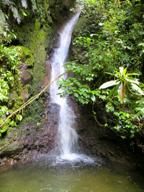
Nauyaca Waterfalls are on the Barú river at the elevation of the village of Platanillo (Highway San Isidro de El General to Dominical). It’s one of the most spectacular waterfalls in Costa Rica. The falls are really five waterfalls. The lower level has two falls and a 1000 sq. meter pool for swimming. The upper level has three falls and an overlook down to the lower pools. In addition, there are quiet pools for bathing all along the river downstream from the falls to the bridge.
Las Cataratas Nauyaca están situadas en el río Barú, a la altura del pueblo de Platanillo en la autopista de San Isidro de El General a Dominical. Son unas de las cataratas más espectaculares de Costa Rica. En realidad son cinco cataratas: El nivel bajo tiene dos caídas y una poza de mil metros cuadrados para nadar. El nivel alto tiene tres cataratas con vista a las pozas de abajo. Además, hay pozas serenas para bañarse a lo largo del río más abajo de las caídas, hacia el puente.


Rio Barú below bridge - bajo el puente.
To get there you drive 10 Km uphill (towards San Isidro), from the Bridge at Dominical. The office is a signed building on the right (south) side of the road 2 Km before Platanillo. The family of Don Lulo are in the business of running horse tours here, but they do have an admission price of $3 for hikers.
The entrance to the waterfalls road/trail is 50 meters uphill from their office and may be unmarked. If you arrive by bus, taxi, or two wheel drive car, you are hiking from here—2 to 2 1/2 hrs each way. If you can drive down to the bridge, the hike is 1 1/2 hrs each way. I think it’s okay to leave a car here, but for those that worry, there is a house across the bridge and about 100 meters up the road that will watch your vehicle for $2. If it’s really hot, you can cool off with a dip in the large river pool under the bridge.
Para llegar allí hay que viajar 10Km cuesta arriba (hacia San Isidro), desde el puente en Dominical. El edificio de la oficina tiene rótulo y está a la derecha (al sur) de la carretera, 2 Km antes de Platanillo. La familia de don Lulo tiene el negocio de alquiler de caballos en este punto y también cobra derecho de admisión de $3 para caminantes.
La entrada al sendero/camino para las cataratas está a 50m más arriba de la oficina y puede que no esté demarcado. Si uno llega en bus, taxi o 2X4, hay que caminar desde aquí —de 2 a 2 1/2 horas tanto la ida como la vuelta. Si puedes conducir hasta el puente, la caminata es de 1 1/2 horas de ida y de vuelta. Creo que se puede dejar el auto acá, pero para los que les da miedo, hay una casa frente al puente, donde te cuidan el auto por $2. Si hace mucho calor, puedes refrescarte en una poza grande bajo el puente.

The trail starts as a road which parallels the Barú river upstream. It is well marked all the way. During rainy season there is more shade on the road, but in dry season it can be hot and sunny. I recommend an early start for both cooler uphill walking, and to avoid the afternoon rains which can be dangerous in any canyon. This is a moderate hike, because there is quite a bit of uphill walking in fairly hot temperatures. At about the halfway point you pass the Don Lulo homestead which has a small rescue zoo and a dinning hall for their horse-trip clients.
The road then deteriorates in quality and keeps going up until you get to two marked trail entrances on the left. The first is for horses and the second is for hikers. The trail then enters the forest as a single track and does a winding descent to the waterfalls. Halfway down this trail you arrive at the spot where they tie up the horses and everyone walks. There are also change rooms for swimsuits and outhouses at this spot. The trail junction for the lower and upper falls is just below the horse rails. I recommend going to the lower falls first since most people are hot at this point, and need a good swim.
El sendero empieza como un camino paralelo al río Barú hacia arriba. Está bien demarcado a todo lo largo. En la estación lluviosa hay más sombra en el camino, pero en la estación seca puede estar caliente y soleado. Yo recomiendo empezar temprano por aquello de caminar más refrescados y para evitar las lluvias de la tarde, que pueden ser peligrosas en cualquier cañón. Esta caminata es moderada, pues tiene bastante camino cuesta arriba en temperaturas altas. Más o menos a la mitad se ve lacasona de don Lulo, con su pequeño zoolólico de rescate y su comedor para los clientes de viajes a caballo.
Aquí el camino se deteriora y continúa subiendo hasta que ves las dos entradas a senderos, a tu izquierda. La primera es para caballos y la segunda para caminantes. El sendero entonces entra en el bosque y empieza a descender hacia las cataratas. A mitad de este sendero hay un lugar donde atan los caballos y todo el mundo camina. También hay vestidores y servicios sanitarios en este punto. Yo recomiendo ir primero a la parte baja de las cataratas, pues uno está caluroso y con ganas de nadar.


These are powerful waterfalls with a lot of spray during most of the year, so expect all the rocks to be slippery. I am not very good barefoot, so I pack sandals or watershoes along with me in the day hike pack. Most swimming holes under waterfalls are not easy in and out because of the rocks, but well worth the effort once you’re in the pool. Diving is dangerous unless you have first checked out the spot of your choice for hidden rocks. The upper falls have a smaller pool, but usually it’s too turbulent and the access across the rocks is very difficult. It’s well worth the hike up since the view is excellent. Hike back the way you came and if you are hot, there is a good swim waiting under the bridge over the Río Barú.
The website for Don Lulo is: http://www.cataratasnauyaca.com
Estas cataratas son poderosas y con mucho riego la mayor parte del año, así que las rocas pueden estar resbalosas. Yo no soy muy hábil descalzo, por lo que llevo sandalias o zapatos de agua. Las pozas bajo cataratas normalmente tienen difícil acceso al meterse y salirse, debido a las rocas, pero son deliciosas una vez adentro. Allí el clavado es peligroso, a no ser que primero revises que el lugar que escogiste no tiene rocas escondidas.
Las cataratas de arriba tienen una poza más pequeña, pero usualmente muy turbulenta y el acceso a través de las rocas es muy difícil. Vale la pena esta caminata, pues la vista allí arriba es excelente.
De vuelta, camina por la misma ruta y si tienes calor, te espera una deliciosa nadada bajo el puente del río Barú.
El sitio web de don Lulo es: http://www.cataratasnauyaca.com

Lower Fall - Caida inferior

Upper Falls - Caida superior
Golfito area: Cataratas y Senderos Avellán: Zona de Golfito
Cataratas y Senderos Avellán
If you’re in Golfito looking to do some hiking, check out the trails and waterfalls at “Cataratas y Senderos Avellán”. Only 6 km north of the Depósito Libre, they have a variety of trails, clean waterfalls with good pools for bathing, a tarzan swing, canopy tour, covered jungle camping,
rooms and a full service restaurant with good typical country food. Great for birders and botanists.
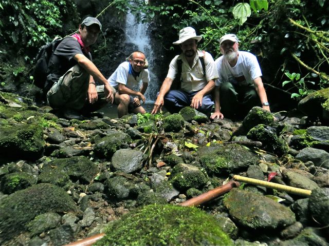
I went with friend, Ted, with the intention to add to my collection of waterfalls, and I was not disappointed. The hiking/waterfall tour is $5 and includes a knowledgeable guide, swim beneath the waterfall, and a swing through the jungle like Tarzan and Jane.
The main trails are well made, and relatively easy. For those with more ambition and time, there is a more difficult 6 Km loop. The water here is crystal clear and the bathing is perfectly refreshing for a hot jungle zone. The property has a combination of farm, and secondary and primary forest. It straddles the Gamba River and is adjacent to Piedras Blancas National Park. We did not stay overnight, but it looks like a great place for wildlife if you did the Jungle camp, or the rooms at the homestead.
Getting There: From the north side of the Depósito Libre (tax free market) in Golfito, turn right at the corner before the technical high school. Go 6 Kms on a hilly gravel road. You’ll see the restaurant and sign on the left side of the road.
There is poor phone service out there, but they do have a web site: www.avellancr.com

Senderos Avellán trails
Si estás en Golfito y te gustaría hacer una caminata, vale la pena que visites las “Cataratas y Senderos Avellán”, a sólo 6 Km al norte del Depósito Libre. El lugar ofrece variedad de senderos, cataratas limpias con buenas pozas para bañarse, un columpio estilo Tarzán, tour de canopy, campamento de jungla cubierto, habitaciones y restaurante con servicio completo de comida típica. Es ideal para observadores de pájaros y botánicos.
Fui con mi amigo Ted, con la intención de ensanchar mi colección de cataratas, y no me decepcionaron. El tour para hiking y la catarata cuesta $5 e incluye guía bastante conocedor de la zona, bañarse bajo la catarata y un columpio en medio de la jungla, como el de Tarzán y Jane.
Los senderos principales están bien hechos y son relativamente fáciles. Para quienes tengan más ambición y tiempo, hay una curva más difícil, de 6Km.
Allí, el agua es cristalina y bañarse es refrescante en medio de la jungla caliente. La propiedad consiste de una combinación de finca y bosque primario y secundario, los cuales hacen puente sobre el Río Gamba y están a la par del Parque Nacional Piedras Blancas.
No nos quedamos la noche, pero parece ser un lugar ideal para vida silvestre, si te quedaras en el campamento de jungla, o en las habitaciones de la finca.
Para llegar: Del lado norte del Depósito Libre en Golfito, doblar a la derecha en la esquina antes del colegio técnico, y seguir 6 Km por calle inclinada sin pavimentar. Verás el restaurante y letrero del lado izquierdo del camino.
Hay mal servicio telefónico, pero sí tienen portal web: www.avellancr.com

Poza Avellán pool

Avellán Catarata

Columpio - swing
Volcán POAS Volcano
Sometimes you see it, sometimes you don’t. However, I strongly recommend being there by opening time at 8:00 a.m.
From the hiking point of view, this is not an important site. However, it’s so much fun to see, and the lagoon is beautiful.
Lo ves, o no lo ves. Por eso recomiendo estar allí a la hora de abrir el parque, a las 8:00 a.m.
Desde el punto de vista del hiking, éste no es un sitio importante. Pero…¡Me encanta verlo! Y la laguna es preciosa.

Cataratas Los Chorros waterfalls

vista Los Chorros

Poás trail - sendero a laguna